Madero Street
Francisco I. Madero Avenue, commonly known as simply Madero Street, is a geographically and historically significant pedestrian street of Mexico City and a major thoroughfare of the historic city center. It has an east–west orientation from Zócalo to the Eje Central. From that point the street is called Avenida Juárez and becomes accessible to one-way traffic from one of the city's main boulevards, the Paseo de la Reforma.
Read article


.jpg)


Top Questions
AI generatedMore questions
Nearby Places

Allende metro station
Mexico City metro station
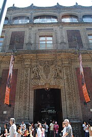
Palace of Iturbide
Former Imperial Palace of Mexico
Church of San Felipe Neri "La Profesa"

Interactive Museum of Economics
Mexican museum dedicated to economics and finance

Borda House, Mexico City

Library of the Congress of Mexico

Templo Expiatorio Nacional de San Felipe de Jesús
Church in Mexico City, Mexico
Casa Pellandini